Geodata Viewer
Online KML, GPX and GeoJSON viewer, for parsing GPS data (points, tracks and routes) and additional extensions from GPX Waypoints Mobile Application.
Recent Activity
GPS Waypoints Enterprise
GPS Waypoints Enterprise is a surveying and mapping application for organizations, using a Web desktop management access, a Mobile APP for Android devices and optionally IoT devices with sensors.
Request TrialWhat is?
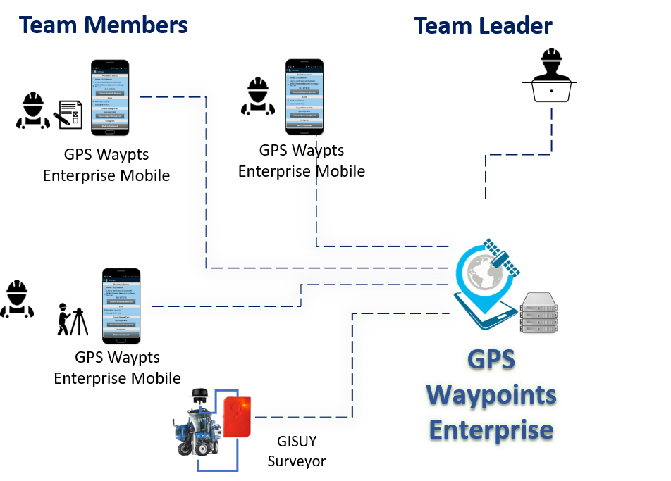
GPS Waypoints Enterprise enhances the GPS Waypoints Premium mobile version, adapting the product to organisations and enterprises, in particular when cooperation between mobile devices are required or specific developments are needed. The enterprise solution focus on teamwork surveys, with professionals (e.g. agriculture) but also volunteers (e.g. emergencies, environment). Custom solutions are possible, including the usage of IoT devices for tracking vehicles.
The application is helpful for several land-based surveying and mapping activities, including agriculture, forest, environment & biodiversity, emergencies and infrastructures maintenance (e.g. roads and electrical networks).

Mobile and Server applications
The solution includes a Web desktop management access, Mobile APPs for Android devices and optionally IoT devices (such as GISUY receiver). The service is requested and setup via web access and activated on the mobile applications.
Features/Advantages
Manages your enterprise surveys:
- Better team coordination and cooperation
- Enables the distribution private tagging schemes to surveyors
- Centralizes the team's collected data in one place making it easier to manage
- Online view of the geodata collected by the mobile devices
- Extract reports from the surveys
Uses a Mobile application widely supported:
- Uses a very mature mobile data acquisition app (operational since 2015)
- Gets surveyors focused on the current tagging scheme of the surveying activity
- Online survey data synchronization between team members (upload and get)
Optionally, integrates external GNSS Receivers:
- Can track vehicles using IoT GNSS receivers with pole mounted antennas
- Can use high precision external GNSS receivers with hand-held based antennas connected to mobile devices
Pricing Plan
There are three main plans available (Single Professional, Small Team, and Large Team), dimensioned according to the size of your team. If you are not sure what version better suits you, request a one-month trial.
Choose PlanPlans start at 8€/month
- Multi-device survey synchronization
- Organizes geodata per survey
- View geodata on map
- Survey waypoints backups